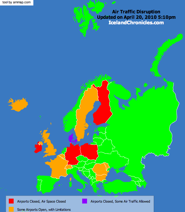
Air traffic disruption will continue through the weekend, with the situation worsening as the ash cloud spreads throughout Central and Eastern Europe. Even countries like Sweden, that had reopened their air space earlier today, had to close it again in the evening. Depending on winds and volcano activity, chaos might continue in the next week. I decided to put together a small flash map for our readers, since we are having many requests for it. The information presented in this map is gathered from press releases, google news, BBC.co.uk, and CNN.com. While I will try to keep the map updated, please rely on these sources for the last-minute updates, but use our map to have a clearer view of the situation. You can bookmark this post and check again later, as I will be updating the map here. The map can be also extremely useful to visualize distribution of the ash cloud – in most cases, red countries are those that already came into contact with the ash cloud.
Please note that the map may look a bit rough, but I had to find a decent tool, learn to use it, and enter the data in 1 hour. The version below is a static image for all those without Flash in their browsers. Click on the image to access the interactive map.
And do not forget to check the ash cloud photos that Pu took today.
LAST MAP UPDATE: (April 20, 2010 – 5:10pm GMT)
A bit of relief in Europe, even though expectations of having good part of the air space open today were ruined when it was announced during the night that a new ash cloud produced by the volcano is now spreading through Europe. U.K. was once again the country to be most affected. Anyhow, as the map shows, many other countries, especially in eastern and southern of Europe, and Norway in the north, have, for the time being, fully reopened their airspace. Situation might change, anyhow, as the eruption is still going at Eyjafjallajökull. Weather reports say that winds might help free the skies of the ash cloud later in the week – even though their direction could mean that the ash cloud might spread further to the north and to the west, affecting more seriously Canada’s air space.
I recommend visiting your airport’s website for more information. This website has a decent list of most airports in the world. You are free to link to the map, as long as credits are given to us.
